Karst Springs
Clarke County
Clarke County is rich with natural springs. The U.S. Geological Survey has identified over 85 perennial or ephemeral springs in the county. The majority of these springs are in areas underlain by limestone bedrock, also referred to as karst terrain.
McKay Spring
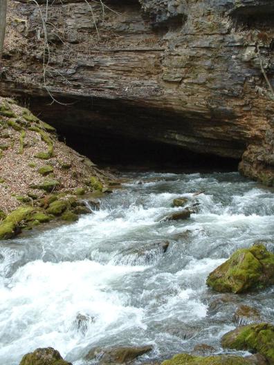
McKay Spring in Cedarville in northern Warren County was quickly tapped as a water supply by European colonists arriving in the Shenandoah Valley in the late 17th and 18th centuries and almost certainly was known to and used by countless generations of Native Americans before them. Built between 1731 and 1734, the McKay house near the spring was the oldest structure in Warren County when it tragically burned in 2009, and the Warren Heritage Society considers its builder, Robert McKay, Jr., to likely be the first settler in Warren County. Upwards of a million gallons of water per day, depending on climatic conditions, flows from this spring, which has never been known to dry up.
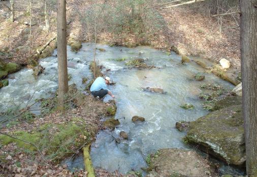
The water flowing from McKay Spring all originated as precipitation falling on the limestone bedrock of the Shenandoah Valley floor, a karst landscape. Rainwater and snow melt works its way downward, taking and dissolving rock with it along its journey before rising at the spring. Investigators from the Virginia Department of Conservation and Recreation and members of the local caving community used geologic mapping and dye tracing to determine that the limestone area to the east of the spring, between present-day 340/522 and the Norfolk Southern railroad, extending north to the Warren County fairgrounds, accounts for a significant portion of the “spring-shed” or recharge area of McKay Spring. In addition, chemical analyses by the U.S. Geological Survey suggest that at least some of the water that flows from McKay Spring has been underground for several decades or even longer, reflecting the complex combination of pathways water takes before arriving at the large springs of the Shenandoah Valley.
Until recently, McKay Spring provided water for a mobile home park at the intersection of US 340 and Cedarville Road. In addition, the Town of Front Royal purchased McKay Spring about 20 years ago for future use as a water supply to support continued economic development along the US 340 corridor.
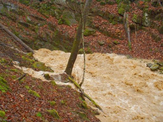
Unfortunately, much of the recharge area for McKay Spring has land uses that place it at risk. In addition to the US 340/522 corridor and the railroad, an industrial area known as the Cedarville Enterprise Zone overlies the recharge area, posing a constant risk of groundwater contamination. This industrial area was well underway before the hydrology of the spring was understood, and Warren County has invested significant resources and enacted policies to reduce the risk to the spring. However, as long as the transportation corridors and industrial park are in place, McKay Spring will need to be closely monitored, especially if it is to be used as a water supply. Even now, the effects of human activity are evident in the chemistry of the water, which includes among other things, consistent but very low levels of chloroform.
Karst Springs of Winchester
Tour Length: Approximately 1 mile. The tour will be all walking on paved and gravel paths, so comfortable shoes are highly recommended.
The tour will start at the Abram's Delight Historic Home and Museum Parking Lot (1340 S. Pleasant Valley Road, same lot as the Visitor Center). Abram's Delight is the oldest standing house in Winchester (c. 1754), and at this site in 1732, Abraham Hollingsworth built a small cabin situated close to several springs that the local Shawnee people assured him were a reliable source of drinking water. The springs were channeled into a lake built in the 19th century by one of Hollingsworth's great grandsons.
Then walk to the Shawnee Springs Preserve, a new park managed by the City of Winchester's Park and Recreation Department, and centered on the historic Shawnee Springs. The 14‑acre preserve protects several natural features including springs, wetlands, and forests. It also contains part of the Sheridan’s Field Hospital site. This temporary federal Civil War facility operated between September 1864 and January 1865 after the Third Battle of Winchester, and was one of the largest field hospitals of the Civil War. The Shawnee Springs were considered sacred by the local Native American people, who attributed healing powers to the water.
All of the springs are developed along an unnamed "transform" fault where there has been horizontal movement of the karst bedrock of at least 4,500 linear feet. Water traveling through fractures and joints that intersect the fault collects in the broken rock- and solution-enlarged fault zone, and emerge as the springs rise where near-surface joints and fractures daylight. The combined output of the Shawnee and Abram's Delight Springs has been estimated at more than 5,000 gallons per minute (7.2 million gallons per day), and it was the presence of these springs that led to the founding of Winchester, just as other springs have determined the locations of nearly all of the major towns and cities in the Great Valley Province of Virginia and West Virginia.